Welcome to our friends and families to Villa Chile
Scenic Routes
The Axarquía region of Andalucía
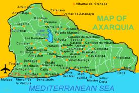
Until about a decade ago the Axarquía region of Andalucía was little known. Then, northern European expatriates started to notice the pretty little villages throughout the region. They started buying up and renovating some of the run-down 'fincas' and farmhouses and really put the area on the map.
Today, rural tourism comprises a pretty large part of the local economy. However, the area still remains breathtakingly beautiful and has not been spoilt by the influx and interest of foreigners.
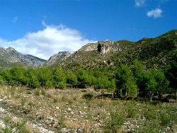
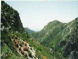
The main attractions are the area's spectacular hill and mountain scenery, its unspoilt, white washed villages and the strong sweet wine that's made from sun drenched grapes which are grown in abundance everywhere.
There are 5 mapped Scenic Routes in Axarquía, each takes in a series of villages and scenery connected by an agricultural or architectual theme. At the bottom of this page we have charted the routes for you which you can see at a glance.
Mudejar Route

The Mudejar Route is 75 kilometres long, entirely inland. It traverses the municipalities of Arenas, Archez, Salares, Sedella and Canillas de Aceituno, each within the foothills of the Almijara and Tejada Sierras. All are small towns and villages with Moorish and Mudejar remains in good repair.
Mudejar architecture is the name given to Muslim architecture developed by Muslims in Christian areas (as opposed to Mozarabic architecture which was developed by Christians in Moorish areas). Some Mudejar buildings are indistinguishable from Muslim buildings but they did evolve distinguishing features of their own.
One was the use of brick for many churches and mansions. Another was extravagantly decorated timber ceilings, often ornately carved. Mudejar style is often found side by side with Christian Gothic in the same building.
Arenas is the starting point of the route and is found 10 kilometres from Velez-Malaga surrounded by countryside containing olives, almonds and vines.
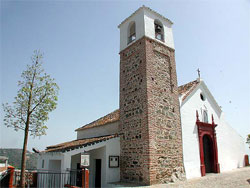
Mudejar tower at Corumbela The road between Arenas and Archez runs via the two small villages of Daimalos and Corumbela, each of which have church towers that were formerly mosque minarets. Daimalos also has a Moorish fountain.
Travelling through green mountain foothills for 7 kilometres, the next stop of the route is Salares. After this stop a short distance of 4 kilometres takes the route to Sedella. The River Rubite, a tributary of the River Velez, runs through this area, as do numerous mountain springs and streams.
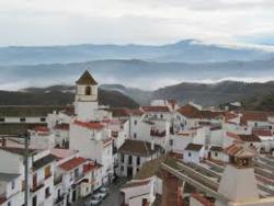
The last stop on the Mudejar Route is a further 8 kilometres from Sedella at Canillas de Aceituno.
The route passes through the Rahiges Nature Reserve and past a spring and waterfall on the right hand side of the road where bathing is possible and barbeque and picnic areas are provided.
Although there are no further official stops on this route, the road back down to Velez-Malaga from Canillas de Aceituno is an enjoyable ride with spectactular views over mountains, valleys and Lake Vinuela.
Return to top menu
Route of the Sun and Wine
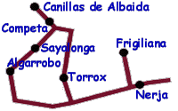
The Route of Sun and Wine is 55 kilometres long, running through the eastern area of Axarquia. It passes both inland and along a stretch of coastline. It traverses the municipalities of Algarrobo, Sayalonga, Competa, Canillas de Albaida, Torrox, Frigiliana and Nerja.
The route includes important tourist resorts at Nerja, Torrox Costa and Algarrobo Costa. The inland villages lie within the foothills of the Sierra Almijara mountain range and have retained much of their original Moorish structure.
The main agricultural product in the areas surrounding these villages is the grape, from which many very good wines are produced.
Algarrobo is the starting point of the Route of Sun and Wine. It is found 5 kilometres to the east of Torre del Mar, along the coastal road N-340, and then 4 kilometres inland. The next stop is a further 5 kilometres on at Sayalonga.
|
< |
The same road takes us another 9 kilometres until reaching Competa. After this stop a short distance of 3 kilometres takes the route to Canillas de Albaida.
To reach the next village on the route we return to Competa and take the road for Torrox which is 15 kilometres on. From Torrox Costa the route follows the coastal N-340 in an easterly direction.
Two watchtowers built in the 16th century for defense over the beaches are found here; the Torre del Morche and the Torre de Calaceite. The fortress of Castle Bago previously stood between these two towers.
After 8 kilometres of following a coastline of cliffs to the left and coves, rocks and small beaches to the right, just before reaching Nerja, a road to the left leads 6 kilometres to Frigiliana.
Two more watchtowers are seen on the coast road before turning off to Frigiliana; these are the Torre Macaca and the Torrecilla.
The last stop on the Route of Sun and Wine is reached by retracing the road from Frigiliana down to Nerja.
Return to top menu
Route of the Raison
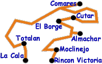
The Route of the Raisin is 62.5 kilometres long, taking in villages and regions of the south-western area of Axarquia through the foothills of the Montes de Malaga.
It traverses the municipalities of Totalan, Comares, Cutar, El Borge, Almachar and Moclinejo. All are small towns and villages with Moorish remains and ambience.
The chief crop is the vine from which the grapes are used to make sun-dried raisins and quality muscatel wine. The landscape is dotted with drying fruit beds.
The route begins in La Cala, an area of Rincon de la Victoria, on the coast and leads, after 9 kilometres, to the first stop at Totalan. The landscape is lowland with soft rolling hills filled with bushes, shrubs, vineyards and almond trees.
After 7 kilometres, the road from Totalan leads through Olias where there is a 16th century church of Sant Vicente Ferrer. Ascending for 20 kilometres, the road passes the peak of Mount Santopitar which has an altitude of 1,020 metres and has beautiful views over the Bay of Malaga and Axarquia, past the ruins of Masmullar to reach Comares.
After 7 kilometres from Comares there is a T-junction at the hamlet of La Zubia. Riogordo is in the direction to the left and north on the Route of Oil and Mountains. To follow the Route of the Raisin we travel right and south through Benamargosa, which is part of the Route of Sun and Avocado, through countryside characterised by gullies and hillocks to Cutar which is 17 kilometres fom Comares.
The next stop on the route is a further 5 kilometres where El Borge is found. Another 2 kilometres brings us to Almachar. The landscape between the two villages is one of gentle slopes covered in vines and fincas with drying beds.
The last stop on the Route of the Raisin is a further 8 kilometres of rolling hillsides from Almachar to Moclinejo. From here it is a further 11 kilometres to reach the coast and Rincon de la Victoria.
Scenic routes, maps and text with courtesy of http://www.absoluteaxarquia.com
Scenic routes at a glance
| Scenic Routes |
Villages on Routes |
| Mudejar Route |
Arenas |
Daimalos |
Corumbela Salares |
Archez |
Salares |
Sedella |
Canillas de Aceituno |
| Route of Sun and Wine |
Algarrobo |
Sayalonga |
Cómpeta |
Canillas de Albaida |
Torrox |
Frigiliana |
Nerja |
| Route of the Raison |
La Cala |
Totalán |
Comares |
Cútar |
El Borge |
Almachar |
Rincon Victoria |
| Route of Sun and Avocado |
Rincón de la Victoria |
Torre del Mar |
Macharaviaya |
Vélez Málaga |
Iznate |
Benamocarra |
Benamargosa |
| Route of Oil and Mountains |
Vinuela |
Alcaucin |
Periana |
Alfarnate |
Alfarnatejo |
Riogordo |
Colmenar |
Thank you for visiting Villa Chile website
Return to top menu
Home |
Weddings |
Home from Home |
Local Amenities |
Local Attractions
Photo Gallery |
Tourist Information |
Competa Walks |
Scenic Routes |
Local Markets
Fiestas |
Local Transport |
Maps & Directions |
Landing Page
Copyright © 2023 Elizabeth F. Paris
Website by Carole Curtis with


